Hours of walk: 3,30
Altitude gain: 600 m
Altitude loss: 850 m
Itinerary
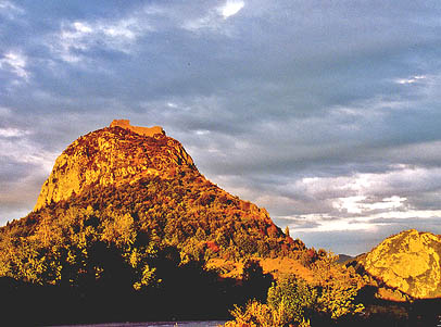
The walk leaves from the west of the village, across fields, and it then enters the shady area of the Gorges de La Frau on a forest track. The track becomes a road (D5) which leads to the rural hamlet of Pelail. You follow the track on the valley floor along the course of the stream Rivels. After walking a steep stretch to the head of the valley at the foot of the Montagne de la Frau, main area of this whole stage, you follow a hillside track through the wood in order to reach a wider upland, where a conifer forest (Forêt du Corret) leaves space to enclosed fields, with a lot of grazing cattle. You then go down to the valley floor of the stream Lasset: after the bridge you go up to the village of Montségur, dominated by the ruins of its castle (to be visited during the following stage).
Food and accommodation
-In Montségur
Chambres d’hôtes L’Oustal
4 rooms, meal service, 46, Le village, tel. 33 (0)5 61 02 80 70, www.montsegur.org .
Gîte d’étape de Monségur
Sleeps 17 in dormitory, reading room, lounge, tel. 33 (0)5 61 01 10 24, www.gite-montsegur.com .
Other options for food and accommodation can be found in town. Office de Tourisme de Monségur, 104, Le Village, tel. 33 (0) 5 61 03 11 27, www.montsegur.fr .