Hours of walk: 3
Rise: 400 m
Drop: 250 m
Itinerary
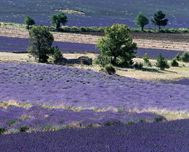
An asphalted road leaves the village leading south until just past the houses of the Village de Vac, where you start walking along a track in the woods. The route follows a well signalled net of un-surfaced roads and forest tracks, in a variegated environment alternating woods (oak trees) and lavender fields. The landscape is dotted with farmhouses and evenly sectioned by dry walls in calcareous stone. You walk across the small village of Aurel and then keep on towards the south. You carry on along dirt roads and forest tracks in the Bois du Défens. Further on, there is an asphalted road to the Place de l’Église, a square lined with false acacias in Sault-en-Provence.
Food and accommodation:
-In Sault-en-Provence:
Gîte d’êtape de la Touche
2 km from the historical centre, on the D 194 towards Mont Ventoux, tel. 04 90 64 07 22.
Office de tourisme de Sault
Avenue de la Promenade, www.saultenprovence.com. Many other options for food and accommodation can be found in hotels, chambres d’hôtes and restaurants.